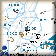
(ESSA) Stockholm Hub
![]()
![]()
Coordinates: 59° 39' 26.00" N 17° 55' 59.00" E
Elevation: 124' MSL
ATIS: 121.62 & 119.00
|
Runway:
1 |
ILS:
(SSA) 109.9mhz 27NM |
Glideslope:
1700ft @ 5NM |
|
Approach Course:
8deg |
Altitude/Surface:
121ft/Concrete |
Length/Width:
10803ft/148ft |
|
Runway:
19 |
ILS:
(NSA) 110.7mhz 27NM |
Glideslope:
1700ft @ 5NM |
|
Approach Course:
188deg |
Altitude/Surface:
121ft/Concrete |
Length/Width:
10803ft/148ft |
|
Runway:
8 |
ILS:
(WSA) 109.55mhz 27NM |
Glideslope:
1700ft @ 5NM |
|
Approach Course:
74deg |
Altitude/Surface:
121ft/Concrete |
Length/Width:
8183ft/148ft |
|
Runway:
26 |
ILS:
(ESA) 110.1mhz 27NM |
Glideslope:
1700ft @ 5NM |
|
Approach Course:
284deg |
Altitude/Surface:
121ft/Concrete |
Length/Width:
8183ft/148ft |
![]()
|
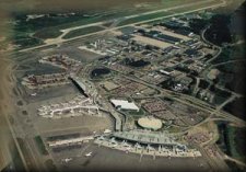
THE scenery for Sweden!!!!
|
![]()
Stockholm - Tel Aviv