(LLBG) Tel Aviv Hub
![]()
![]()
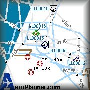
Coordinates: 32° 0' 34.20" N 34° 52' 36.83" E
Elevation: 135' MSL
ATIS: 132.5
|
Runway:
8 |
ILS:
(BA) 108.7mhz 27NM |
Glideslope:
1700ft @ 5NM |
|
Approach Course:
77deg |
Altitude/Surface:
134ft/Asphalt |
Length/Width:
12093ft/149ft |
|
Runway:
26 |
ILS:
(BA) 108.7mhz 27NM |
Glideslope:
1700ft @ 5NM |
|
Approach Course:
257deg |
Altitude/Surface:
134ft/Asphalt |
Length/Width:
12093ft/149ft |
|
Runway:
12 |
ILS:
(BG) 110.3mhz 27NM |
Glideslope:
1700ft @ 5NM |
|
Approach Course:
119deg |
Altitude/Surface:
134ft/Asphalt |
Length/Width:
10395ft/148ft |
|
Runway:
30 |
ILS:
(BG) 110.3mhz 27NM |
Glideslope:
1700ft @ 5NM |
|
Approach Course:
299deg |
Altitude/Surface:
134ft/Asphalt |
Length/Width:
10395ft/148ft |
![]()
|
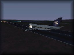
LLBG (Ben Gurion) Scenery Ver 4.7 for
FS2000 Copyright 2001 - by our very own Alexander Lawrence
|
|
|
LLBG (Ben Gurion) EOAC addon for Scenery
Ver 4.7 for FS2000 Also by our very own Alexander Lawrence.
|
![]()