(LFPG) Paris Hub
![]()
Image to go here...
![]()
Coordinates: 49° 0' 46.00" N 2° 33' 0"
E
Elevation:
ATIS: 128.00
|
Runway:
9 |
ILS:
(CGE) 110.10mhz 27NM |
Glideslope:
2000ft @ 5NM |
|
Approach Course:
89deg |
Altitude/Surface:
383ft/Asphalt |
Length/Width:
11793ft/148ft |
|
Runway:
27 |
ILS:
(CGW) 110.7mhz 27NM |
Glideslope:
2000ft @ 5NM |
|
Approach Course:
383deg |
Altitude/Surface:
383ft/Asphalt |
Length/Width:
11793ft/148ft |
|
Runway:
08R |
ILS:
(DSE) 108.55mhz 27NM |
Glideslope:
2000ft @ 5NM |
|
Approach Course:
88deg |
Altitude/Surface:
383ft/Concrete |
Length/Width:
8858ft/197ft |
|
Runway:
8L |
ILS:
(GLE) 108.7mhz 27NM |
Glideslope:
2000ft @ 5NM |
|
Approach Course:
89deg |
Altitude/Surface:
383ft/Concrete |
Length/Width:
13812ft/148ft |
|
Runway:
26R |
ILS:
(GAU) 109.1mhz 27NM |
Glideslope:
2000 @ 5NM |
|
Approach Course:
269 deg |
Altitude/Surface:
383t/Concrete |
Length/Width:
13812ft/148ft |
|
Runway:
26L |
ILS:
(DSU) 108.35mhz 27NM |
Glideslope:
2000 @ 5NM |
|
Approach Course:
268deg |
Altitude/Surface:
383ft/Concrete |
Length/Width:
8858ft/197ft |
![]()
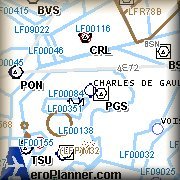
IFR Charts
Charts provided by Team FSS
![]()
![]()
![]()
|
Fix For Charles de Gaulle
Airport |
You must obtain free personal account lfpgfix.zip |
|
FSTraffic Tracks For Paris
FSTraffic/FS2000 Airport 2000 Volume 1 tracks for Paris Charles-de-gaulle Airport (LFPG). Generates a dense traffic with multiple tracks (ground, approach and departure) for every runway (9,27,8L,8R,26R,26L). Every aircraft starts or stops at the terminal. By Gilles Ruppert |
You must obtain free personal account fst_lfpg.zip |
![]()